


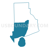
South Rhode Island--Washington County PUMA, Rhode Island
About
Outline

Summary
| Unique Area Identifier | 193937 |
| Name | South Rhode Island--Washington County PUMA |
| State | Rhode Island |
| Area (square miles) | 562.76 |
| Land Area (square miles) | 329.23 |
| Water Area (square miles) | 233.53 |
| % of Land Area | 58.50 |
| % of Water Area | 41.50 |
| Latitude of the Internal Point | 41.40116160 |
| Longtitude of the Internal Point | -71.61761180 |
Maps
Graphs
Select a template below for downloading or customizing gragh for South Rhode Island--Washington County PUMA, Rhode Island


Neighbors
Neighoring Public Use Microdata Area (by Name) Neighboring Public Use Microdata Area on the Map
- Central Rhode Island--Kent County--Warwick City PUMA, RI
- New London County (North) PUMA, CT
- New London County (South) PUMA, CT
- Southeast Rhode Island--Newport & Bristol Counties--Newport City PUMA, RI
- Suffolk County (East) PUMA, NY
Top 10 Neighboring County (by Population) Neighboring County on the Map
- Suffolk County, NY (1,493,350)
- New London County, CT (274,055)
- Kent County, RI (166,158)
- Washington County, RI (126,979)
- Newport County, RI (82,888)
Top 10 Neighboring County Subdivision (by Population) Neighboring County Subdivision on the Map
- Warwick city, Kent County, RI (82,672)
- South Kingstown town, Washington County, RI (30,639)
- North Kingstown town, Washington County, RI (26,486)
- Westerly town, Washington County, RI (22,787)
- Southold town, Suffolk County, NY (21,968)
- East Hampton town, Suffolk County, NY (21,457)
- Stonington town, New London County, CT (18,545)
- Portsmouth town, Newport County, RI (17,389)
- Narragansett town, Washington County, RI (15,868)
- East Greenwich town, Kent County, RI (13,146)
Top 10 Neighboring Place (by Population) Neighboring Place on the Map
- Warwick city, RI (82,672)
- Westerly CDP, RI (17,936)
- Wakefield-Peacedale CDP, RI (8,487)
- Kingston CDP, RI (6,974)
- Pawcatuck CDP, CT (5,624)
- Narragansett Pier CDP, RI (3,409)
- Hope Valley CDP, RI (1,612)
- Ashaway CDP, RI (1,485)
- Bradford CDP, RI (1,406)
- Carolina CDP, RI (970)
Top 10 Neighboring Elementary School District (by Population) Neighboring Elementary School District on the Map
- Exeter-West Greenwich Regional School District, RI (12,560)
- Jamestown School District, RI (5,405)
- Voluntown School District, CT (2,603)
Top 10 Neighboring Unified School District (by Population) Neighboring Unified School District on the Map
- Warwick School District, RI (82,672)
- South Kingstown School District, RI (30,639)
- North Kingstown School District, RI (26,486)
- Chariho Regional School District, RI (23,723)
- Westerly School District, RI (22,787)
- Stonington School District, CT (18,545)
- Portsmouth School District, RI (17,389)
- Narragansett School District, RI (15,868)
- School District Not Defined, NY (13,644)
- East Greenwich School District, RI (13,146)
Top 10 Neighboring State Legislative District Lower Chamber (by Population) Neighboring State Legislative District Lower Chamber on the Map
- Assembly District 1, NY (149,382)
- Assembly District 2, NY (142,833)
- State House District 45, CT (24,378)
- State House District 43, CT (23,842)
- State House District 33, RI (15,503)
- State House District 38, RI (14,987)
- State House District 69, RI (14,799)
- State House District 35, RI (14,728)
- State House District 39, RI (14,717)
- State House District 29, RI (14,512)
Top 10 Neighboring State Legislative District Upper Chamber (by Population) Neighboring State Legislative District Upper Chamber on the Map
- State Senate District 1, NY (341,254)
- State Senate District 18, CT (102,472)
- State Senate District 37, RI (31,690)
- State Senate District 34, RI (30,357)
- State Senate District 38, RI (28,713)
- State Senate District 13, RI (27,057)
- State Senate District 35, RI (27,037)
- State Senate District 36, RI (26,880)
- State Senate District 11, RI (26,852)
- State Senate District 30, RI (25,173)
Top 10 Neighboring 111th Congressional District (by Population) Neighboring 111th Congressional District on the Map
- Congressional District 2, CT (729,771)
- Congressional District 1, NY (705,559)
- Congressional District 2, RI (533,546)
- Congressional District 1, RI (519,021)
Top 10 Neighboring Census Tract (by Population) Neighboring Census Tract on the Map
- Census Tract 507, Washington County, RI (8,188)
- Census Tract 506, Washington County, RI (7,708)
- Census Tract 515.02, Washington County, RI (7,258)
- Census Tract 505, Washington County, RI (6,425)
- Census Tract 208, Kent County, RI (6,135)
- Census Tract 513.06, Washington County, RI (6,032)
- Census Tract 209.03, Kent County, RI (5,985)
- Census Tract 508.01, Washington County, RI (5,907)
- Census Tract 509.01, Washington County, RI (5,893)
- Census Tract 514, Washington County, RI (5,677)
Top 10 Neighboring 5-Digit ZIP Code Tabulation Area (by Population) Neighboring 5-Digit ZIP Code Tabulation Area on the Map
- 02889, RI (28,217)
- 02852, RI (22,551)
- 02891, RI (21,198)
- 02879, RI (20,371)
- 02818, RI (18,082)
- 02882, RI (14,184)
- 06379, CT (9,038)
- 02881, RI (7,841)
- 02813, RI (7,831)
- 02817, RI (6,135)