


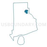
Providence City PUMA, Rhode Island
About
Outline

Summary
| Unique Area Identifier | 193933 |
| Name | Providence City PUMA |
| State | Rhode Island |
| Area (square miles) | 20.57 |
| Land Area (square miles) | 18.40 |
| Water Area (square miles) | 2.17 |
| % of Land Area | 89.46 |
| % of Water Area | 10.54 |
| Latitude of the Internal Point | 41.82305560 |
| Longtitude of the Internal Point | -71.41877950 |
Maps
Graphs
Select a template below for downloading or customizing gragh for Providence City PUMA, Rhode Island


Neighbors
Neighoring Public Use Microdata Area (by Name) Neighboring Public Use Microdata Area on the Map
- Northeast Rhode Island--Providence County--Pawtucket & Central Falls Cities PUMA, RI
- Northwest Rhode Island--Providence County (West & Central)--Woonsocket City PUMA, RI
- Providence County (Southeast)--Cranston & East Providence Cities PUMA, RI
Top 10 Neighboring County (by Population) Neighboring County on the Map
Top 10 Neighboring County Subdivision (by Population) Neighboring County Subdivision on the Map
- Providence city, Providence County, RI (178,042)
- Cranston city, Providence County, RI (80,387)
- Pawtucket city, Providence County, RI (71,148)
- East Providence city, Providence County, RI (47,037)
- North Providence town, Providence County, RI (32,078)
- Johnston town, Providence County, RI (28,769)
Top 10 Neighboring Place (by Population) Neighboring Place on the Map
- Providence city, RI (178,042)
- Cranston city, RI (80,387)
- Pawtucket city, RI (71,148)
- East Providence city, RI (47,037)
Top 10 Neighboring Unified School District (by Population) Neighboring Unified School District on the Map
- Providence School District, RI (178,042)
- Cranston School District, RI (80,387)
- Pawtucket School District, RI (71,148)
- East Providence School District, RI (47,037)
- North Providence School District, RI (32,078)
- Johnston School District, RI (28,769)
Top 10 Neighboring State Legislative District Lower Chamber (by Population) Neighboring State Legislative District Lower Chamber on the Map
- State House District 13, RI (15,978)
- State House District 9, RI (15,152)
- State House District 5, RI (15,066)
- State House District 7, RI (15,013)
- State House District 12, RI (14,854)
- State House District 6, RI (14,823)
- State House District 1, RI (14,723)
- State House District 62, RI (14,595)
- State House District 10, RI (14,425)
- State House District 11, RI (14,402)
Top 10 Neighboring State Legislative District Upper Chamber (by Population) Neighboring State Legislative District Upper Chamber on the Map
- State Senate District 4, RI (30,565)
- State Senate District 3, RI (29,774)
- State Senate District 26, RI (28,899)
- State Senate District 25, RI (28,769)
- State Senate District 6, RI (28,476)
- State Senate District 1, RI (28,358)
- State Senate District 15, RI (28,092)
- State Senate District 7, RI (28,026)
- State Senate District 2, RI (27,838)
- State Senate District 17, RI (27,116)
Top 10 Neighboring 111th Congressional District (by Population) Neighboring 111th Congressional District on the Map
Top 10 Neighboring Census Tract (by Population) Neighboring Census Tract on the Map
- Census Tract 16, Providence County, RI (8,540)
- Census Tract 147, Providence County, RI (7,344)
- Census Tract 18, Providence County, RI (7,114)
- Census Tract 124.01, Providence County, RI (6,950)
- Census Tract 24, Providence County, RI (6,760)
- Census Tract 29, Providence County, RI (6,760)
- Census Tract 118, Providence County, RI (6,734)
- Census Tract 3, Providence County, RI (6,714)
- Census Tract 14, Providence County, RI (6,693)
- Census Tract 104, Providence County, RI (6,661)
Top 10 Neighboring 5-Digit ZIP Code Tabulation Area (by Population) Neighboring 5-Digit ZIP Code Tabulation Area on the Map
- 02860, RI (45,199)
- 02909, RI (43,540)
- 02920, RI (37,547)
- 02908, RI (37,467)
- 02904, RI (29,359)
- 02919, RI (28,790)
- 02906, RI (28,387)
- 02907, RI (27,445)
- 02905, RI (25,223)
- 02914, RI (21,963)