


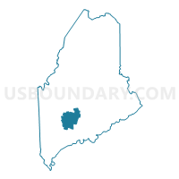
Kennebec County PUMA, Maine
About
Outline

Summary
| Unique Area Identifier | 193037 |
| Name | Kennebec County PUMA |
| State | Maine |
| Area (square miles) | 951.17 |
| Land Area (square miles) | 867.52 |
| Water Area (square miles) | 83.65 |
| % of Land Area | 91.21 |
| % of Water Area | 8.79 |
| Latitude of the Internal Point | 44.41701190 |
| Longtitude of the Internal Point | -69.76576390 |
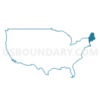
Maps
Graphs
Select a template below for downloading or customizing gragh for Kennebec County PUMA, Maine


Neighbors
Neighoring Public Use Microdata Area (by Name) Neighboring Public Use Microdata Area on the Map
- Androscoggin County PUMA, ME
- Coastal Maine Region--Hancock, Knox, Waldo & Lincoln Counties PUMA, ME
- Northwest Maine--Oxford, Somerset, Franklin & Piscataquis Counties PUMA, ME
- Sagadahoc & Cumberland (North) Counties--Bath City & Brunswick PUMA, ME
Top 10 Neighboring County (by Population) Neighboring County on the Map
- Kennebec County, ME (122,151)
- Androscoggin County, ME (107,702)
- Somerset County, ME (52,228)
- Waldo County, ME (38,786)
- Sagadahoc County, ME (35,293)
- Lincoln County, ME (34,457)
- Franklin County, ME (30,768)
Top 10 Neighboring County Subdivision (by Population) Neighboring County Subdivision on the Map
- Augusta city, Kennebec County, ME (19,136)
- Waterville city, Kennebec County, ME (15,722)
- Skowhegan town, Somerset County, ME (8,589)
- Winslow town, Kennebec County, ME (7,794)
- Fairfield town, Somerset County, ME (6,735)
- Oakland town, Kennebec County, ME (6,240)
- Winthrop town, Kennebec County, ME (6,092)
- Gardiner city, Kennebec County, ME (5,800)
- Sabattus town, Androscoggin County, ME (4,876)
- Jay town, Franklin County, ME (4,851)
Top 10 Neighboring Place (by Population) Neighboring Place on the Map
- Augusta city, ME (19,136)
- Waterville city, ME (15,722)
- Winslow CDP, ME (7,794)
- Gardiner city, ME (5,800)
- Winthrop CDP, ME (2,650)
- Fairfield CDP, ME (2,638)
- Oakland CDP, ME (2,602)
- Hallowell city, ME (2,381)
- Farmingdale CDP, ME (1,970)
- Randolph CDP, ME (1,772)
Top 10 Neighboring Unified School District (by Population) Neighboring Unified School District on the Map
- School Administrative District 75, ME (19,474)
- Augusta, ME (19,136)
- Regional School Unit 18, ME (18,975)
- School Administrative District 09, ME (17,838)
- School Administrative District 54, ME (17,242)
- Waterville, ME (15,722)
- School Administrative District 49, ME (14,994)
- Regional School Unit 12, ME (14,838)
- Regional School Unit 02, ME (14,524)
- School Administrative District 11, ME (13,712)
Top 10 Neighboring State Legislative District Lower Chamber (by Population) Neighboring State Legislative District Lower Chamber on the Map
- State House District 28, ME (9,362)
- State House District 67, ME (9,361)
- State House District 80, ME (9,344)
- State House District 45, ME (9,275)
- State House District 78, ME (9,227)
- State House District 75, ME (9,226)
- State House District 83, ME (9,119)
- State House District 58, ME (9,042)
- State House District 87, ME (8,914)
- State House District 79, ME (8,811)
Top 10 Neighboring State Legislative District Upper Chamber (by Population) Neighboring State Legislative District Upper Chamber on the Map
- State Senate District 18, ME (38,950)
- State Senate District 17, ME (38,831)
- State Senate District 23, ME (38,786)
- State Senate District 24, ME (38,252)
- State Senate District 21, ME (38,170)
- State Senate District 20, ME (38,039)
- State Senate District 26, ME (37,802)
- State Senate District 14, ME (37,295)
- State Senate District 19, ME (36,965)
- State Senate District 25, ME (36,885)
Top 10 Neighboring 111th Congressional District (by Population) Neighboring 111th Congressional District on the Map
Top 10 Neighboring Census Tract (by Population) Neighboring Census Tract on the Map
- Census Tract 106, Kennebec County, ME (7,159)
- Census Tract 9668, Somerset County, ME (6,735)
- Census Tract 242, Kennebec County, ME (6,656)
- Census Tract 465, Androscoggin County, ME (6,492)
- Census Tract 108.02, Kennebec County, ME (6,430)
- Census Tract 250, Kennebec County, ME (6,240)
- Census Tract 9755, Lincoln County, ME (6,122)
- Census Tract 140, Kennebec County, ME (6,092)
- Census Tract 9702, Sagadahoc County, ME (5,950)
- Census Tract 9751, Lincoln County, ME (5,276)
Top 10 Neighboring 5-Digit ZIP Code Tabulation Area (by Population) Neighboring 5-Digit ZIP Code Tabulation Area on the Map
- 04901, ME (26,248)
- 04330, ME (26,086)
- 04345, ME (11,646)
- 04976, ME (9,903)
- 04938, ME (9,869)
- 04963, ME (7,238)
- 04937, ME (6,645)
- 04280, ME (6,474)
- 04364, ME (6,025)
- 04239, ME (4,851)