


Lincoln Trail Area Development District (East) PUMA, Kentucky
About
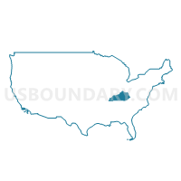
Outline
+PUMA%2c+Kentucky_A280.png)
Summary
| Unique Area Identifier | 192977 |
| Name | Lincoln Trail Area Development District (East) PUMA |
| State | Kentucky |
| Area (square miles) | 1,539.74 |
| Land Area (square miles) | 1,520.75 |
| Water Area (square miles) | 18.98 |
| % of Land Area | 98.77 |
| % of Water Area | 1.23 |
| Latitude of the Internal Point | 37.65915450 |
| Longtitude of the Internal Point | -85.46001450 |
Maps
+PUMA in Kentucky.png)
Graphs
Select a template below for downloading or customizing gragh for Lincoln Trail Area Development District (East) PUMA, Kentucky
+PUMA%2c+Kentucky_T0.png)
+PUMA%2c+Kentucky_T1.png)
+PUMA%2c+Kentucky_T2.png)
+PUMA%2c+Kentucky_T3.png)
+PUMA%2c+Kentucky_T4.png)
+PUMA%2c+Kentucky_T5.png)
+PUMA%2c+Kentucky_T6.png)
+PUMA%2c+Kentucky_T7.png)
+PUMA%2c+Kentucky.png)
Neighbors
Neighoring Public Use Microdata Area (by Name) Neighboring Public Use Microdata Area on the Map
- Barren River Area Development District (Outer) PUMA, KY
- Bluegrass Area Development District (South) PUMA, KY
- Bluegrass Area Development District (West) PUMA, KY
- KIPDA Area Development District (Southeast) PUMA, KY
- Lake Cumberland Area Development District (West) PUMA, KY
- Lincoln Trail Area Development District (West) PUMA, KY
Top 10 Neighboring County (by Population) Neighboring County on the Map
- Hardin County, KY (105,543)
- Bullitt County, KY (74,319)
- Nelson County, KY (43,437)
- Boyle County, KY (28,432)
- Grayson County, KY (25,746)
- Taylor County, KY (24,512)
- Anderson County, KY (21,421)
- Mercer County, KY (21,331)
- Marion County, KY (19,820)
- Hart County, KY (18,199)
Top 10 Neighboring County Subdivision (by Population) Neighboring County Subdivision on the Map
- Elizabethtown CCD, Hardin County, KY (49,288)
- Bardstown CCD, Nelson County, KY (26,012)
- Harrodsburg CCD, Mercer County, KY (13,653)
- West Spencer CCD, Spencer County, KY (11,334)
- Lebanon CCD, Marion County, KY (10,231)
- Shepherdsville Southeast CCD, Bullitt County, KY (10,172)
- Springfield CCD, Washington County, KY (8,950)
- Hodgenville CCD, Larue County, KY (7,914)
- Coxs Creek CCD, Nelson County, KY (7,378)
- Taylorsville CCD, Spencer County, KY (5,727)
Top 10 Neighboring Place (by Population) Neighboring Place on the Map
- Elizabethtown city, KY (28,531)
- Bardstown city, KY (11,700)
- Lebanon city, KY (5,539)
- Hodgenville city, KY (3,206)
- Springfield city, KY (2,519)
- Lebanon Junction city, KY (1,813)
- New Haven city, KY (855)
- Bloomfield city, KY (838)
- Loretto city, KY (713)
- Upton city, KY (683)
Top 10 Neighboring Unified School District (by Population) Neighboring Unified School District on the Map
- Hardin County School District, KY (85,779)
- Bullitt County School District, KY (74,319)
- Nelson County School District, KY (30,498)
- Grayson County School District, KY (25,746)
- Anderson County School District, KY (21,421)
- Marion County School District, KY (19,820)
- Mercer County School District, KY (18,592)
- Spencer County School District, KY (17,061)
- Casey County School District, KY (15,955)
- Taylor County School District, KY (15,911)
Top 10 Neighboring State Legislative District Lower Chamber (by Population) Neighboring State Legislative District Lower Chamber on the Map
- State House District 25, KY (51,532)
- State House District 50, KY (49,478)
- State House District 55, KY (45,145)
- State House District 19, KY (44,553)
- State House District 18, KY (43,650)
- State House District 51, KY (43,168)
- State House District 17, KY (42,990)
- State House District 24, KY (41,610)
- State House District 26, KY (41,345)
- State House District 54, KY (40,149)
Top 10 Neighboring State Legislative District Upper Chamber (by Population) Neighboring State Legislative District Upper Chamber on the Map
- State Senate District 20, KY (133,454)
- State Senate District 7, KY (128,013)
- State Senate District 22, KY (126,095)
- State Senate District 14, KY (120,817)
- State Senate District 10, KY (120,533)
- State Senate District 5, KY (115,364)
- State Senate District 15, KY (115,239)
- State Senate District 9, KY (112,974)
Top 10 Neighboring 111th Congressional District (by Population) Neighboring 111th Congressional District on the Map
- Congressional District 2, KY (760,032)
- Congressional District 6, KY (759,205)
- Congressional District 1, KY (686,989)
Top 10 Neighboring Census Tract (by Population) Neighboring Census Tract on the Map
- Census Tract 16, Hardin County, KY (9,402)
- Census Tract 17, Hardin County, KY (8,881)
- Census Tract 10.02, Hardin County, KY (8,344)
- Census Tract 9303.02, Nelson County, KY (8,057)
- Census Tract 9302, Nelson County, KY (7,378)
- Census Tract 10.01, Hardin County, KY (6,762)
- Census Tract 9302, Washington County, KY (6,705)
- Census Tract 9305, Nelson County, KY (6,349)
- Census Tract 9601.02, Larue County, KY (6,212)
- Census Tract 9602, Mercer County, KY (5,809)
Top 10 Neighboring 5-Digit ZIP Code Tabulation Area (by Population) Neighboring 5-Digit ZIP Code Tabulation Area on the Map
- 42701, KY (48,194)
- 40165, KY (32,726)
- 40004, KY (28,245)
- 42718, KY (24,312)
- 40342, KY (21,125)
- 40330, KY (19,334)
- 40071, KY (14,292)
- 40033, KY (12,355)
- 42539, KY (10,026)
- 42748, KY (8,706)